For a full and clearer view, please click here for the first sheet and here for the second.
خريطتان لطنطا، مصر، نشرتهما مصلحة المساحة عام ١٩٢٨. تم مسحهما بين عامي ١٩٢٤ إلى ١٩٢٦ ومراجعتهما عام ١٩٢٦. لرؤية أكثر وضوحا للخريطة الأولى، يرجى الضغط هنا، وللثانية اتباع هذا الرابط.
Maps of Tantah, Egypt, published in 1928 by Maṣlaḥat al-Misāḥah (Survey Dept.), from Egypt town series 1-5,000. Both Show major road network, populated places, public utility, service buildings, agricultural land, and irrigation canals. The town portion of both sheets were compiled from Tanta 1:1,000 maps surveyed in 1924-26 and revised in 1926. The outlying area was compiled from 1:2,500 originals surveyed in 1926. Heights are given in meters above Mean sea-level at Alexandria.
Original Collection: American Geographical Society Library.
Repository: American Geographical Society Library, University of Wisconsin-Milwaukee Libraries.
Repository: American Geographical Society Library, University of Wisconsin-Milwaukee Libraries.
Digital Publisher: American Geographical Society Library Digital Map Collection
Rights: https://uwm.edu/libraries/digital-collections/copyright-digcoll/
Map showing part of Markaz Tanta, 1915. Please click here for a full view. Credit: Ahmed Yehia.
خريطة تبين جزء من مركز طنطا، ١٩١٥. لرؤية كاملة، يرجى اتباع هذا الرابط. شكر خاص للأستاذ أحمد يحيى.
Map of Mudiriyet el-Gharbiya, el-Minufiya and el-Beheira, 1915. Please click here for a full view.
خريطة مديريات الغربية والمنوفية والبحيرة، ١٩١٥. لرؤية كاملة، يرجى اتباع هذا الرابط.
Collection name: David Rumsey Historical Map Collection.
Author: Wizarat al-Maliyah (Ministry of Finance) and Maslahat al-Misahah (Survey Dept.), Egypt.
Publisher: Government Press, Cairo
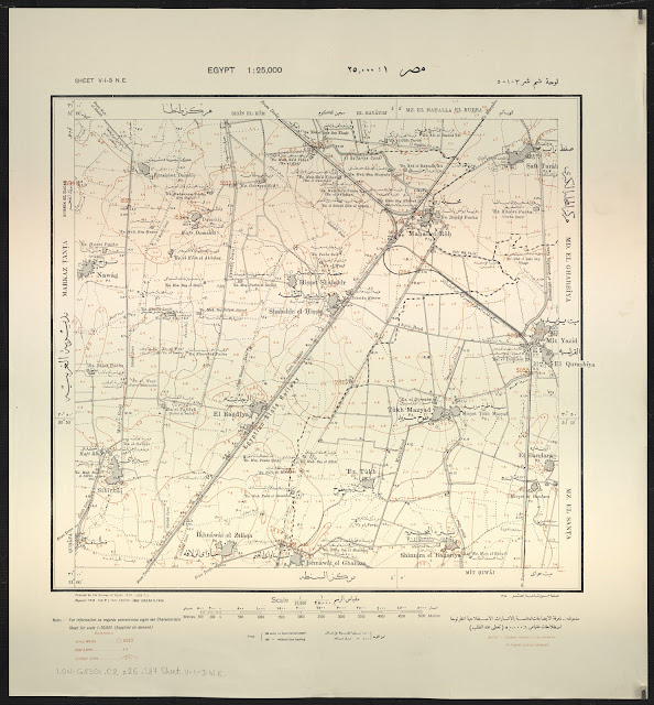
Map showing parts of Tantah, El Mahalla el-Kubra and El Santa in the Gharbiya Governorate, 1918. Please click here for a full view.
خريطة تبين أجزاء من طنطا والمحلة الكبرى والسنطة بمديرية الغربية، ١٩١٨. لرؤية كاملة، يرجى اتباع هذا الرابط.
Repository: United Nations Library & Archives Geneva


